Hurricane Irene Gains Steam
ACE Staff
|August 26, 2011
First a 6.0 magnitude earthquake hits the east coast, something that hasn’t happened since 1944 when a 5.8 magnitude quake hit Massena, NY. Now, Hurricane Irene is set to hurtle through the Northeast. It has been a crazy week for weather patterns, and the earth.
According to the Associated Press, “Federal officials have warned Irene could cause flooding, power outages or worse all along the East Coast as far north as Maine, even if it stays offshore. The projected path has gradually shifted to the east and Irene could make landfall anywhere from South Carolina to Massachusetts over the weekend.”
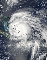
Hurricane Irene passed over the Bahamas on Thursday and is scheduled to touch down in North Carolina on Thursday. News sources say that it is well on its way to becoming a category 4 storm. New York City, New Jersey, Connecticut, North Carolina, Maryland, and Virginia have all declared states of emergency as the storm gains speed up the coast.
According to the National Hurricane Center, the storm is predicted to touch down in New York City on Sunday. This would be the first storm to hit the island in 25 years. It will bring with it heavy winds and rain of up to 79 miles per hour. That would be like if Godzilla landed and then sneezed really, really hard. You don’t want to be in the way of a Godzilla sneeze.
What does this mean? We don’t know anything yet about frequency, but intensity is likely to increase with warming oceans. Hurricane Irene prepares to blow through the Northeast, we can’t help but thinking if this storm has been made worse by climate change. The temperature of the Atlantic Ocean has increased, and ocean heat is what gives storms their power. Think of it this way: oceans are like huge jet packs for Irene. The more her jet pack is charged up, the more energy she’ll have. Also, the Atlantic Ocean is 13 inches higher now than it was a century ago. The extra foot on the ocean will help propel the storm surge, which is the huge wall of water that the hurricane pushes in front to help clear its path. It is the storm surge that causes the most damage. Irene is using her jet pack to propel and the storm surge like a powerful force field. That combination makes her a powerful evil superhero of a storm.
Check out the National Weather Center’s National Hurricane Center Storm Surge Interactive Risk Map.
If you live in an area that is expected to feel the effects of the hurricane, start preparing now. CNN has warned that the storm will cause travel delays, especially for planes and trains, but be smart about any vehicle use if your area is at risk. Also make sure your home is safe by securing storm shutters if needed, making sure all loose plants around your house are tied down, and checking rain gutters to make sure they are not clogged. Also talk to your neighbors for emergency contacts or consider starting a neighborhood hurricane safety team.
Join our Youth Action Network
More Blog Posts

Our Climate Wins Were on Display at the State of the Union
Today, the Biden Administration temporarily halted all pending decisions on 17 Liquefied “Natural” Gas (LNG) projects across the Gulf South.
Read More
ACE Honored As An Anthem Awards Finalist
Action for the Climate Emergency (ACE) announced today that it won Bronze in Best Use of AI at the 3rd …
Read More
BREAKING: Biden Halts LNG Export Expansion
Today, the Biden Administration temporarily halted all pending decisions on 17 Liquefied “Natural” Gas (LNG) projects across the Gulf South.
Read More